Authors: L. Piepoli, A. Fino, S. Capurso, M. de Sio, M. Pellegrino, M. Sciscio
Download article as .pdf: Report delle prime indagini topografiche in località Minerva: un sito pluristratificato nella chora di Taranto
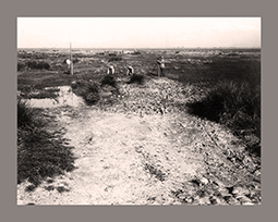
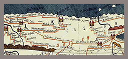
 The data obtained during the topographic surveys carried out in 2022 on the multi-layered site of the Minerva locality (Castellaneta-TA) are presented. Previous unsystematic studies have shown the presence in the area of remains of ancient walls, some architectural elements and numerous fictile finds outcropping on the surface, generally datable between the prehistoric and Roman periods. Recent research has made it possible to define the chronological and settlement peculiarities of the site better than in the past, highlighting an early phase of peopling the area between the Middle and Late Bronze Ages and the presence of a continuous active settlement, albeit with different settlement forms depending on the period, between the 6th and early 2nd centuries BC. The research also included a Medieval rocky village located along the side of the Castellaneta ravine, bordering the ancient site to the north, which can be identified with the Minerva settlement mentioned in Guidone’s Geographica in the 12th century among the settlements located along the road between Oria (BR) and Acerenza (PZ).