Author: L. Idà
Download article as.pdf: Lapicidineæ (Perrieræ hodie dictæ) sunt, quas Macharenses fuisse. Latomie antiche a Vendicari (SR)
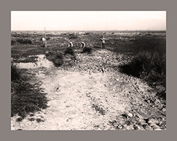
 Tommaso Fazello is doubtless one of the founders of historical topography in Sicily. Thanks to his periegetic activity of archaeological research and his discoveries, the majority of the main Sicilian archaeological locations have been identified. The subject of this paper is the stone quarries near the port of Vendicari, mentioned by Tommaso Fazello in relation to the city of Maccara for which the exact location is still unknown. Based on survey activities conducted during a PhD research, some stone quarries have been documented in the coastal area of Vendicari saltwater swamps, located into three distinguished areas. According to technical and topographic aspects, these quarries can provide useful research ideas for the association between stone pulled out and ancient settlements, including Maccara.